My Email addres: Farzad.Mostafavi@live.com
***لطفا با ارسال نظرات خود در هرچه بهتر شدن مطالب این وبلاگ بنده را راهنمایی فرمایید***هرگونه کپی مطالب از این وبلاگ مجاز می باشد*** با تشکر از بازدید شما
آدرس جدید و بدون فیلتر وبلاگ به همراه کلیه مطالب قبلی http://farzadmostafavi.blog.com

Lecture Notes

NOTE: The lecture notes below are available for free download as PDF files. Simply click a title to download it. The quality of the images in some of these documents varies and depends on the quality of the scanned originals.
LN # Title
15 Matrices (5 MB)
16 Coordinate Systems in Geodesy (13 MB)
18 The Method of Least Squares (14 MB)
22 The Least Squares Approximation (7 MB)
23 Brief Outline of the Molodenskij Theory (3 MB)
25 Earth-Pole Wobble (3 MB)
27 Tensors (9 MB)
32 Gravimetric Satellite Geodesy (10 MB)
34 Systematic Analysis of Distortions in Map Projections (2 MB)
35 Introduction to Adjustment Calculus (20 MB)
36 The Earth Tides (4 MB)
37 Conformal Map Projections in Geodesy (12 MB)
39 Geodetic Position Computations (10 MB)
40 Aerotriangulation (13 MB)
42 A Synthesis of Recent Advances in the Method of Least Squares (11 MB)
48 Mathematical Models for Horizontal Geodetic Networks (3 MB)
49 Introduction to Geodetic Astronomy (17 MB)
54 Style Manual for the Department of Geodesy and Geomatics Engineering (8 MB)
55 Photogrammetry for Civil and Forest Engineers (11 MB)
57 Photogrammetry: The Concepts (31 MB)
58 Guide to GPS Positioning (106 MB)

http://gge.unb.ca/Pubs/LectureNotes.html
Last updated 2006-February-1

Coordinate Systems in Geodesy (13 MB)

دانلود چند جزوه و نمونه سوال نقشه یرداری

دانلود نمونه سوالات امتحانی


دانلود لیستسی از سایت های دانلود کتاب


دانلود کتب آموزشی نرم افزارهای نقشه بردای

Photomode دانلود کتاب آموزش نرم افزار


جزوه نقشه برداری


جزوه نکته و تست درس نقشه برداری کلاسهای آمادگی برای کنکور کارشناسی ارشد- مهندس فروتن -17 صفحه-6.8 مگابایت فایل PDF - کلمه عبور "farid"

استفاده از سیستم LIDAR در هیدروگرافی

یکی از سیستم های جدید گردآوری اطلاعات توپوگرافی و اصول روش های تهیه نقشه استفاده از سیستم های لیدار است که هرچند مدت زیادی از پیدایش و استفاده از این تکنولوژی نمی گذرد ولی به سرعت جای خود را در بین روش های گردآوری اطلاعات در رشته نقشه برداری باز نموده است

اساس کار سیستم های لیدار اندازه گیری فاصله به کمک شعاع لیزر است که با داشتن موقعیت نقطه تابش شعاع لیزر و هم چندین المان های توجیه خارجی ابزار اندازه گیری – مشابه وضعیت توجیه خارجی در سیستم های عکس برداری هوایی – امکان محاسبه مختصات نقطه اندازه گیری شده وجود خواهد داشت.

نمونه ای از خروجی یک سیستم لیدار

هر چند می توان به روش های رایج فتوگرامتری نیز به همین اطلاعات رسید ولی به دلیل برخی از محدودیت های که در روش فتوگرامتری وجود دارد استفاده ازاین روش خصوصا در نواحی که تهیه مدل رقومی زمین از اهمیت بیشتر برخوردار است و عوارض پلانیمتری با اختلاف ارتفاع زیاد در آن کم است می تواند روش به مراتب سریع تر و کم هزینه تری باشد چرا که در روش فتوگرامتری برای رسیدن به مختصات هر نقطه نیاز به اخذ حداقل دو تصویر با شرایط هندسی خاص است در خالی که در روش لیدار مختصات هر نقطه صرفا به کمک یک اندازه گیری قابل محاسبه است .


در ثانی در روش فتوگرامتری برای رسیدن به حالت بهینه هزینه و دقت باید ابزار اندازه گیری در سیستم پرنده ای نصب شود که امکان پرواز در ارتفاع مورد انتظار را داشته باشد و در همچنین توانایی حفظ پایداری سیستم برای اخذ تصاویر قائم را داشته باشد به صورتی که المان های دوران فی و امگا و کاپا ی تصویر کوچک باشند. در حالی که در سیستم های لیدار هرچند نمی توان گفت این پارامتر ها حذف شده اند ولی به مراتب کم اهمیت تر از روش فتوگرامتری می باشند لذا دامنه انتخاب وسیله پرنده و همچنین محدودیت های پروازی خصوصا در نواحی کوهستانی شدید با ارتفاع پرواز پایین که در روش فتوگرامتری باعث بروز محدودیت های زیادی می کند در روش مبتنی بر سیستم های لیدار این محدودیت ها به مراتب کمتر است.

حال چند صباحی است که با افزایش دامنه برد و قابلیت های نفوذ شعاع لیزر و همچنین مدل سازی اختلاف بین باز تاب شعاع لیزر از سطح آب و بازتاب کف دریا ، امکان استفاده از همین تکنولوژی در عمق یابی و تهیه نقشه های هیدروگرافی نیز بوجود آمده است و سیستم های تجاری آن نیز در دسترس جامعه نقشه برداری قرار گرفته است بگونه ای که حتی برخی از شرکت های نقشه برداری حوزه خلیج فارس نیز امکان ارائه خدمات در این زمینه را دارا می باشند - امیدواریم جامعه نقشه برداری کشور نیز در این زمینه هر چه زودتر فعال گردند

در انتها لازم به ذکر است که هنوز قابلیت نفوذ شعاع لیزر در این سیستم های آنقدر بالا نیست که در تمامی موارد قابل استفاده باشند و صرفا برای نقشه برداری نواحی کم عمق و نزدیک به ساحل یا رودخانه ها می توان از آنها استفاده کرد

نمونه ای از خروجی یک سیستم لیدار

منبع

Google Earth


Download Google Earth 5.1.7894.7252 | ِDownload

Google Chrome 5 | Download

جزوات کلاسی درس فتوگرامتری 4 دکتر صمدزادگان


در 9 درس (کلمه عبور جهت باز کردن جزوات "student-4")

1- Photo-4-Ch1-Introduction-Final.pdf

2- Photo-4-Ch2-StripAdjustment-Final.pdf

3- Photo-4-Ch3-Independent-Model.pdf

4- Photo-4-Ch4-Bundle-Final.pdf

5- Photo-4-Ch5-GCP-Final.pdf

6- Photo-4-Ch6-Auxilliary-Final.pdf

7- Photo-4-Ch7-AdditionalFinal.pdf

8- Photo-4-Ch8-Accuracy-Final.pdf

9- Photo-4-Ch9-Combined-Final.pdf

جهت دانلود بر روی لینک ها راست کلیک کرده و گزینه Save Target As را انتخاب کنید

کتاب و جزوات درس فتوگرامتری


دانلود کتاب Pattern recognition نوشته theodoridis - ویرایش سوم - حجم 39 مگابایت


دانلود کتاب Introduction to Statistical Pattern Recognition, 2nd Edition نوشته fukunaga - حجم 12 مگابایت


کتاب DIGITAL TERRAIN MODELING Principles and Methodology - زبان اصلی- حجم 15.6 مگابایت فایل

PDF

جزوه فتوگرامتری 1 - تهیه شده توسط جناب آقای مهندس هادی عقیلی- فایل pdf حجم 448 کیلو بایت -

جزوه فتوگرامتری 2 - تهیه شده توسط جناب آقای مهندس هادی عقیلی- فایل pdf حجم 1.94 مگابایت -

دانلود جزوات ژئودزی


جزوه نجوم ژئودتیک مهندس محمد کریم (انتشار جزوه تایپی برای اولین بار بر روی نت) دانلود pdf ، حجم 3.04 مگابایت


جزوه درس میکروژئودزی ، اردوی کارورزی، نوشته جناب آقای مهندس به نبیان. (8 صفحه Jpg)


جزوه خلاصه درس فیزیکال ژئودزی - کلاس کنکور کارشناسی ارشد مهندس فروتن - دانشگاه تهران پاییز 86 - در 2 بخش:

- بخش اول فایل word به حجم 4.22 مگابایت

- بخش دوم فایل word به حجم 3.79 مگابایت


جزوه نکته و تست درس نقشه برداری کلاسهای آمادگی برای کنکور کارشناسی ارشد- مهندس فروتن -17 صفحه-6.8 مگابایت فایل PDF - کلمه عبور "farid"


جزوه نجوم و ژئودزی ماهواره ای دکتر میر قاسم پور - فایل pdf حجم 3.94 مگابایت - 35 صفحه دست نویس کلاسی


جزوه GPS دکتر عبادی- تایپی-36 صفحه- 3.4 مگابایت - pdf


جزوه تئوری خطاها و سرشکنی


دانلود چند برنامه برای دانلود

Free Download Manager 2.5 | Download

Accelerator Plus 9.4 | ِDownload

Internet Download Manager 5.1 | Download


Free YouTube Download | Download

Nitro Downloader 3.0 | Download

دانلود چند نرم افزار متفرقه در مورد نقشه برداری


BoxPlot.

Download this software (BoxPlot1_0.zip 3.9 Mb)

hance

Download this software (Chance.zip 2.5 Mb).

Spatial Domain Calculator

Download this software (DomCalc.zip 2.51 Mb).

GeoJPEG2Shp.

Download this software (Chance.zip 2.5 Mb).

Net2IE

Download this software (Net2IS.zip 1.78 Mb).

Pheno-Calc.

"A method to incorporate phenology into land cover change analysis".

Download this software (pheno-calc.zip 4.6 Mb).

Proctor!.

Download this software (Proctor-Wver.zip 2.59 Mb).

Query Tool +

Download this software (qtool+.zip 10.0 Mb).

XML Parser

"Developing a Geospatial Search Tool Using a Relational Database Implementation of the FGDC CSDGM Model".

Download this software (XMLParser.zip v.2.0, 1.4 MB)


Association software دانلود نرم افزار


Download this software (Assoc1.zip 1.64 Mb).

برای اطلاعات بیشتر بر روی این لینک کلیک کنید

"A Method for Assessing Independence of Animal Locations with Association Matrices".

دانلود کتب و آئیین نامه ها در مورد مبنا ی ارتفاعی - سطح آزاد آبهای آزاد


Data Collection Platform References


A1. Next Generation Water Level Measurement System (NGWLMS) Site Design, Preparation, and Installation Manual (NGWLMS Manual), January 1991 (PDF) 29.7 meg.

A2. Xpert Operations and Maintenance Manual, October 2006 (PDF) 2.29 meg.

Sensor References


B1. User's Guide For 8200 Acoustic Gauge (Installation and Operation), Updated August 1998 (PDF) 200k

B2. User's Guide For 8200 Bubbler Gauge (Installation and Operation), Updated February 1998 (PDF) 100k

B3. User's Guide For 8210 Bubbler Water Level Gauge For Hydrographic Surveying Applications (Installation and Operation), February 2001 (PDF) 4.7 meg.

B4. Barometer Calibration Guidelines for Suton XPERT DCP Systems, Updated November 2008 (PDF) 22k

B5. Wind Sensor Alignment Procedure for the R. M. Young Wind Monitor, October 2005 (PDF) 351k

B6. Sutron Accubar Barometer Field Calibration Procedures Updated February2008 (PDF) 187k

B7. CO-OPS Sensor Specifications and Measurement Algorithms (PDF) 56k

Benchmarks, Leveling And Geodetic References


C1. User's Guide for the Installation of Bench Marks and Leveling Requirements for Water Level Stations, October 1987 (PDF) 19 meg.

C2. User's Guide For Writing Bench Mark Descriptions, Updated January 2002 (PDF) 115k

C3. User's Guide For Electronic Levels, Updated January 2003 (PDF) 2.3 meg.

C4. User's Guide For GPS Observations, Updated December 2009 (PDF) 2.7 meg.

C5. CO-OPS GPS Observations Implementation Plan, January 2003 (PDF) 31k

C6. NOAA Technical Memorandum "NOS NGS-58, Guidelines for Establishing GPS-Derived Ellipsoid Heights (Standards 2 cm and 5 cm), version 4.3", November 1997

C7. Standards and Specifications for Geodetic Control Networks, Federal Geodetic Control Committee, September 1984.

C8. Setting a NGS 3-D Monument, July 1996 (PDF) 109k

C9. Attachment R, Requirements for Digital Photographs of Survey Control, NGS, January 2008 (PDF) 90k

C10. Real-Time Kinematic (RTK) Team Final Report (PDF) 325k

C11. Attachment T, Setting a Concrete Mark (PDF) 70k

C12. Attachment U, Setting a Survey Disk in Bedrock (PDF) 51k

C13. Attachment X, Performing Bench Mark Ties (PDF) 100k

Reconnaissance References


D1. CO-OPS Water Level and Meteorological Site Reconnaissance Procedures, Updated May 2009 (PDF) 94k
D2. CO-OPS Current Meter Reconnaissance Procedures, Updated April 2007 (PDF) 50k
D3.

Guidelines for Meteorological Station Reconnaissance and Meteorological Sensor Height Measurements, Updated May 2009 (PDF) 614k

Contract Specifications and References


E1. CO-OPS Specifications and Deliverables for Installation, Operation, and Removal of Water Level Stations, Updated November 2008 (PDF) 198k.

E2. NOS Hydrographic Surveys Specifications and Deliverables, May 2008

E3. Environmental Field Services Statement Of Objectives (PDF) 590k

E4. Water Level Station Specifications and Deliverables for Shoreline Mapping Projects, Updated May 2009 (PDF) 260k

References for National Water Level Program


F1. Standing Project Instructions For Coastal and Great Lakes Water Level Stations, December 2009 (PDF) 222k

F2. 2010 Project Instructions, Installation, Operation, Maintenance, and Removal of Coastal and Great Lakes Water Level Stations (PDF) 623k

F3. Standard Operating Procedure, SOP-06-001 for Upgrading an Existing Water Level Station or Installing a New Water Level Station, Updated August 2007 (PDF) 46.1k

F4. CO-OPS Evaluation Criteria for Water Level Station Documentation, May 2006 (PDF) 43k

F5. Water Level Station - Xpert Site Report, March 2007 (PDF) 27k

F6. Amendment No. 1 - 2007 Project Instructions, Installation, Operation, Maintenance, and Removal of Coastal And Great Lakes Water Level Stations (PDF) 255k

F7. Great Lakes - Establishment of International Great Lakes Datum (1955) (PDF) 2.1M

F8. Great Lakes - Establishment of International Great Lakes Datum (1985) (PDF) 1.7M

F9. Great Lakes - IGLD85 USACE Update No. 76 (PDF) 595k

F10. Great Lakes - History of Water Level Gauges - Upper Great Lakes & the St. Clair Detroit Rivers - Jan 1978 (PDF) 4.3M

F11. Great Lakes - History of Water Level Gauges - Lower Great Lakes & International Section of St. Lawrence River - Mar 1987 (PDF) 13.M

F12. E-Site User's Guide - revision 1.3-1 (PDF) 450k

F13. Engineering Bulletin 09-003 Update to Xpert Log File Sizes, November 13, 2009 (PDF) 31k

References for National Current Observation Program


G1. NAO xxx-xxx Charter Vessel Safety (rev.1) (PDF) 46k

Communications and Data Formats References


H1. NGWLMS GOES Message Formatting For Hourly Transmissions, January 2003 (PDF) 78k

H2. Technical Report NOS CO-OPS 030 - NWLON/DMS Quality Control Software (QC): Functional Requirements Documents (PDF) 19.0 meg.

H3. Information Systems Branch PORTS Uniform Flat File Format (PUFFF) (PDF) 166k

H4. Spatial Data Modifications and Enhancements (v1.2), August 2005 (PDF) 124k

H5. Ocean Systems Test and Evaluation Program Data Communications Plan (PDF) 9.9 meg.

H6. NWS Guide to the Use of NWLON and PORTS Computer-Based Products (PDF) 1.0 meg.

References for Modeling Program


I1. (Currently in revision)

Data Processing and Analysis References


J1. Tide Datums and Their Applications - NOAA Special Publication NOS CO-OPS 1 (PDF) 2.3 meg.

J2. Computational Techniques for Tidal Datums Handbook - NOAA Special Publication NOS CO-OPS 2 (PDF) 2.3 meg.

J3. Tidal Current Analysis Procedures and Associated Computer Programs - NOAA Technical Memorandum NOS CO-OPS 021 (PDF) 750k

ARC View دانلود نرم افزار


Download this software (ReWrite.zip 1.73 Mb)

دانلود چند کتاب و مجله درحوزه جزر و مد و هیدرو گرافی


POPULAR PUBLICATIONS

  1. CO-OPS Customer Satisfaction Survey Results (PDF) 160kb.
  2. Elevated East Coast Sea Level Anomaly: June-July 2009 (PDF) 2.2 meg.
  3. CO-OPS Strategic Plan 2010-2015 (PDF) 11.6 meg.
  4. CO-OPS Trifold (PDF) 10.1 meg.
  5. PORTS® Program (PDF) 534kb.
  6. COASTAL Program (PDF) 1.5 meg.
  7. National Currents Program (PDF) 1.6 meg.
  8. NOAA Sentinels of the Coast (PDF) 663kb.
  9. Understanding Tides (PDF) 1.9 meg.
  10. Estimating Economic Benefits from NOAA PORTS Information - A Case Study of Houston/Galveston (PDF) 601k
  11. CO-OPS Contribution to NOAA's 2005 Hurricane Season Response (PDF) 851k
  12. 150 Years of Tides on the Western Coast (PDF) 200k
  13. Our Restless Tides
  14. San Francisco Tides of History (PDF) 142K
  15. Tide and Current Glossary (PDF) 600k
  16. Fantastic Tidal Datums (PDF) 4.4 meg.
  17. Estimating Economic Benefits from NOAA PORTS Information - A Case Study of Tampa Bay (PDF) 229k
  18. Tidal Currents Educational Pamphlet #4 (PDF) 8.63 meg.
  19. Network Gaps Analysis for the National Water Level Observation Network - NOAA Technical Memorandum NOS CO-OPS 048 (PDF) 9.53 meg.
  20. Understanding Sea Level Change (PDF) 1.1 meg.
  21. Sea Level Variations of the United States, 1854 - 2006 - NOAA Technical Report NOS CO-OPS 053 (PDF) 5 meg.
  22. Initial Operational Deployment Report, Miros Air Gap Sensor and Laser Sensor at the Verrazano-Narrows Bridge (PDF) 725k

دانلود چند کتاب در مورد نقشه برداری ژئودتیک


Executive Summaries are available here. Full reports can be requested from the Project Manager.

pdf Anchorage, Alaksa (AK08) Survey Report Executive Summary. Final version, April 6, 2009.

pdf Puerto Rico and the Virgin Islands (PV09 and VIlow09) Survey Report Executive Summary. Final version, June 23, 2009.

pdf Fairbanks, Alaksa (AK09) Survey Report Executive Summary. Final version, September 28, 2009.


مقالات علمی و نشریات متفرقه

pdf "How NOAA’s GRAV-D Project Impacts and Contributes to NOAA Science", May 7, 2010.

html GRAV-D Relation to NOAA Annual Guidance Memorandum, August 5, 2009.

pdf GRAV-D Project Plan. Final version, December 19, 2007.


موارد تحصیلی

ppt NGS Gravity and Geoid Brown Bad Lunch Talk, January 19, 2010. "Geoid Computations At NGS: Where Are We And Where Are We Going?"

ppt NGS Gravity and Geoid Brown Bag Lunch Talk, December 1, 2009. "GRAV-D on the Airfield: How we accomplish airborne gravity data collection." Also download these movies to view the entire presentation: movie1 (2Mb, gravimeter sensor self-leveling); movie2 (186Mb, landing the NOAA Cessna Citation on St. Thomas, VI)

ppt NGS Gravity and Geoid Brown Bag Lunch Talk, November 3, 2009. "Airborne Gravity Processing 101."


مقالات علمی و تخصصی

ppt FEMA Briefing on the NSRS and GRAV-D, September 15, 2009.

ppt GRAV-D Project Update presentation to the International Association of Geodesy conference in Buenos Aires, Argentina, September 2, 2009.
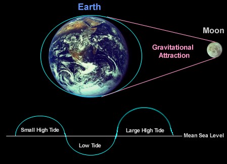
دانلود کتاب GRAV-D

Google Earth/KML Files


CO-OPS has begun offering its products via KML to users of Google Earth.

Sea Levels

Tide Predictions

  • Google Earth KML Icon NOAA Tide Predictions - NOAA Tide Prediction locations, including links to daily, weekly, and monthly tide predictions.

CO-OPS Water Level Stations

  • Coming soon!

CO-OPS Current Stations

  • Google Earth KML Icon Historic Data - A list of historic current survey stations. Data for each station is available for various depths.

NGS GEOID


Last updated 2010/02/03

The National Geodetic Survey has released updated models for transforming heights between ellipsoidal coordinates and more physical height systems that relate to water flow. These models cover all regions including the conterminous United States (CONUS), Alaska, Hawaii, Guam and the Commonwealth of the Northern Mariana Islands, and American Samoa. Models for Puerto Rico and the U.S. Virgin Islands are being held back pending release of final control data for the USVI but will likely be released later this Fall. GEOID09 transforms to NAVD 88 in CONUS and Alaska and to the respective datums for all the other regions (each having its own datum point). Models for the Deflection of the Vertical have also been released for these same regions mainly for aid in navigation systems.


Latest models


Hybrid Geoids - Converts heights from NAD 83 to regional Vertical datums (e.g., NAVD 88 for CONUS)


Gravimetric Geoids - Converts heights from ITRFxx to the NGS geoid surface (not NAVD 88 or other Vertical datums)


Vertical Deflection Models

دانلود کتاب Global Positioning

Tutorial PDF (pdf, 6.9Mb)

Global Positioning

Image of two men on a geodetic survey expedition in 1922

(Members of a 1922 geodetic survey expedition. Click on the image for larger view.)

Geodesy is the science which makes global positioning possible. Geodesy is literally the science of measuring and monitoring the size and shape of the Earth and the location of points on its surface. NOAA's National Geodetic Survey (NGS) is responsible for the development and maintenance of a national geodetic data system that is used for navigation, communication systems, and mapping and charting.

The Global Positioning Tutorial is an overview of the history, essential elements, and modern methods of geodesy.

The Roadmap to Resources complements the information in the tutorial, leading you to additional information and data resources from NOAA and other reliable resources.

دانلود چند کتاب در مورد سنجش از راه دور

1 | 2 | 3